Interviews
Historical fortress wall discovered in man’s backyard using ‘georeferenced’ map from Utrecht University
Dutch version of this article.
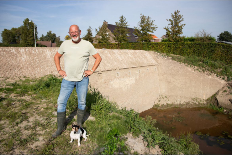
While deepening a pond in his garden, Erwin Jesterhoudt from the Zeeland village of Philippine, stumbled upon a piece of an old wall in early October. Using a digital historical map from Utrecht University, he learned that it was a section of an 18th-century fortress wall. The Centre for Digital Humanities spoke with Jesterhoudt about his discovery and the fortification map of Philippine.
Georeferencing in Philippine
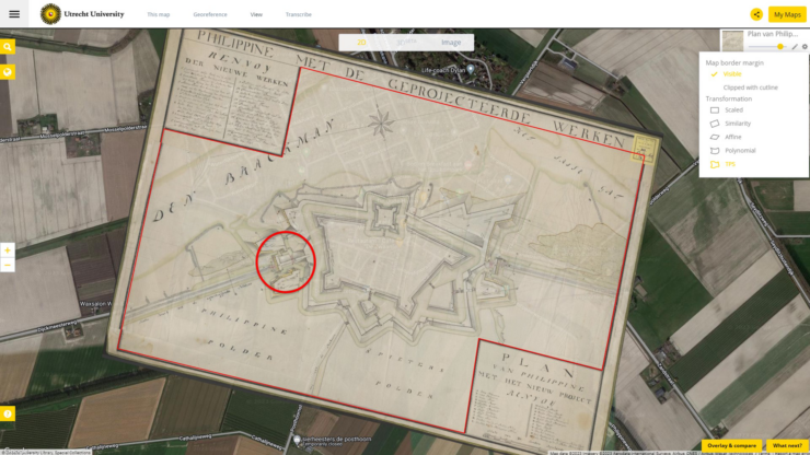
Jesterhoudt: “I knew little about the history of Philippine when I found the wall. I’ve only been living here for a year. I simply started searching for maps on Google, and that’s when I came across Utrecht University, which had a beautiful map from 1751 on its website, along with the option to overlay it onto a new one.”
Overlaying old maps onto new ones is called georeferencing: by virtually putting a historical map onto a modern reference map, you can see changes over time. For the past ten years, staff of the Special Collections of Utrecht University Library have been working on this. Through online crowdsourcing, around 3,500 historical maps have been made digitally accessible. Using the OldMapsOnline-application, anyone can compare these georeferenced maps with the current situation.
Through this application, Jesterhoudt realized that the fortress wall of Philippine runs right through his garden. Jesterhoudt: “The 1751 map aligns best with the points. The GPS coordinates from the older maps didn’t match exactly. The further back in time you go, the more variation you find.”
‘Stenen Beer’
After confirming this historical discovery, Jesterhoudt decided to further excavate the wall. The wall is now 10 by 5 meters and still not completely unearthed. “It has been underground for a long time, yet it’s in excellent condition and still has a good colour.”
Two archaeologists from Artefact!, hired by the Terneuzen municipality, have determined that it’s a so-called ‘Stenen Beer’, a stone dam in the old canal of the fortress. At that time, Philippine was located on an offshoot of the Westerschelde river. The Stenen Beer separated the canal from the sea water. In case of an attack, the sluices that ran through the Beer allowed them to flood the canals of Philippine.
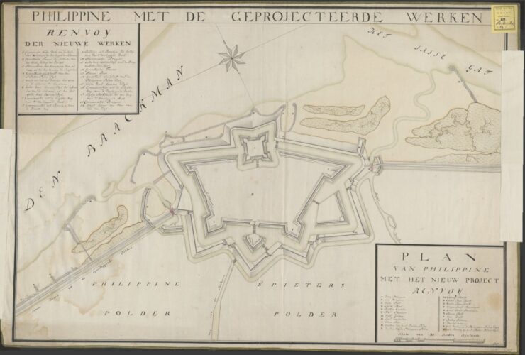
The 1751 map that Jesterhoudt used, was a fortification plan for the Philippine fortress, hand-drawn by a (likely military) engineer. Philippine served as a strategic harbor fortress for a long time and underwent shifts in control between the Spanish and the French. When the town reverted to Dutch authority in 1749, they wanted to strengthen the fortress for better future defense. The fortification plan includes various fortification enhancements and an inundation system for defense. However, it wasn’t an execution plan, so it’s still not entirely clear what was actually built in practice.
Puzzle piece
With Jesterhoudt’s discovery, another historical puzzle piece has been found. Jesterhoudt: “It is now clear that the wall corresponds to the Westbeer (west dam) in the fortification plan. It is almost a copy of the Oostbeer (east dam), which was already known. Archaeologists weren’t sure if the Westbeer had actually been built, so that was a surprise. The sluices that ran through the wall were once located under my neighbor’s shed. They were made of wood and were removed in the past. After World War II, a lot was demolished in the village. My house is slightly outside the village center, so maybe that’s why the wall was left intact. For this Westbeer, they chose to bury it with soil rather than remove it. It was cheaper.”
Jesterhoudt has been visited by various media outlets and has has become a local celebrity. Jesterhoudt: “I’ve joined the Historical Society of Philippine and am hearing more and more stories about the history of this village. It’s incredibly fascinating, and that’s why I think it’s important to preserve the wall. The idea now is that on special open days, visitors can come and see the wall. The cement in the wall is very strong, so it doesn’t need preservation. But if there’s funding, we could restore it to its original state.”
In an article by Omroep Zeeland, historical geographer Marc Buize advises people not to immediately start digging in their backyard for historical remains, but first to explore archives and study historical maps. And now, thanks to tools like OldMapsOnline and the georeferenced maps, by Utrecht University and other organisations, this is accessible to everyone.
Read more
- Want to find out if there’s a historical artifact in your backyard? Create a free account through OldMapsOnline to search for georeferenced maps by location.
- On October 23, the University Library and the Centre for Digital Humanities are organizing a workshop on georeferencing. There are still a few spots available, so sign up quickly if you’d like to join.
- Read more about the Fortification plan of Philippine.
- Read more about the georeferencing process by Utrecht University.