Events
UB & CDH Workshop: Visualizing spatial data on the georeferenced maps of the Special Collections
During this unique demo-workshop Ruben Schalk, Information- and Collection Specialist at the University Library, will show and teach you how to integrate the digitized maps of the Special Collections or your own dataset into data visualizations within a few steps.
The famous seventeenth-century ‘Atlas Maior’ van Blaeu, contains hundreds of detailed maps from across the world. Recently, all the maps from this atlas have been georeferenced and made publicly available on the georeferencer page of Utrecht University, where they can be browsed and compared with each other and current maps.
But did you know that you can also integrate these maps into data visualizations? Within a few steps, you can use these high-resolution old maps to visualize spatial data, such as countries, cities, landmarks, etc. In this demo the presenter will demonstrate how to select georeferenced maps from the Special Collections, and use open-source software to make attractive and even interactive data visualizations that you can publish online. You’ll also work with an example dataset, or a dataset of your own, to learn how to do this yourself.
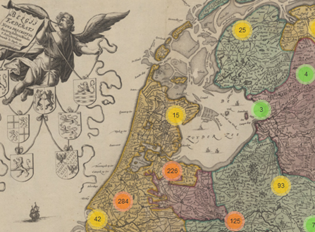
Historical interactive map
Admission is free, but the number of participants is limited, so please register as soon as possible (first come, first served). If you are unable to attend, please cancel your registration by sending an email to CDH@uu.nl, so another participant can take your place.
Please note: the Centre for Digital Humanities aims to promote digital literacy amongst staff-members. When taking this course, the CDH will automatically settle a DCU compensation of 8 hours with your department, which equals 0,36 DCUs (this is double the actual time investment).